Fees & Payments
Application fees
All development applications incur fees in order for the assessment process to be undertaken.
The fees that will be payable for your application depend on what you are proposing.
The types of fees and charges may include:
- Lodgement fees
- Assessment - planning fees
- Assessment - land division fees
- Assessment - building fees
- Assessment - building envelope plan fees
- Homebuilder development fees
- Compliance fees
- Urban tree canopy fees
- Referral agency fees
See what development application fees may apply to your development or download this handy fees and charges at a glance (PDF, 209.7 KB) guide.
Online payments
Once an application has been submitted and verified, payment is required. There are several ways to make your payment.
Go to Online Payments and have at hand your application ID number and the ‘Fee Advice’ number. These details are contained in your ‘Request to Make a Payment’ and the ‘Fee Advice’ notices.
Go to Application Login and log in to ‘Your Application’ account.
Use these guides to further understand how to make a payment for development applications online and explore payment options:
How to - Make an application fee payment within PlanSA
How to - Make an application fee payment within your application
How to - Print application fee payment documents - fee advice and tax invoice
Community Toolkit
This toolkit is designed to help members of the community understand the planning system and access key information that is relevant to you on the PlanSA portal. Please select from the list of actions below:
Tracking a development application and Have your say
Public notification lets neighbours and other interested parties have a say about a development before a decision is made. You can view all currently notified developments on the PlanSA portal.
When you have your say on a notified development application, it’s called ‘submitting a representation’. You can submit your representation online or directly to the planning authority, so long as it is submitted in writing.
To understand what you should include in your submission, read our guide on how to have your say.
All applications lodged through PlanSA are published on the Development Application Register.
You can search the Register and find developments that are occurring near you by entering a specific address or by searching a council area.
You can be notified directly about development occurring near you by subscribing to receive email notification of applications on the Development Application Register. Click the ‘Subscribe to be Notified’ button to choose your council area and frequency of notification.
All Code Amendments are published on the PlanSA portal. The Code Amendment process includes a number of detailed steps which must be undertaken before any changes to zoning or policy in the Planning and Design Code can be implemented.
You can have your say on a Code Amendment when it is ‘On Consultation’. There is a number of ways to make a submission depending on who has initiated the Code Amendment. Click on the title of the Code Amendment you wish to comment on and scroll down to ‘Submission details - have your say’.
You can be notified directly about Code Amendments by subscribing to receive Code Amendment email notifications. Click the ‘Subscribe to be notified’ button on the Code Amendment webpage to receive an email when the status of your selected Code Amendment changes.
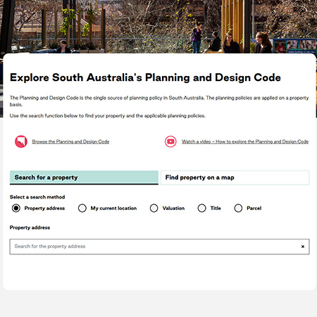
What policies apply to a property
The Planning and Design Code covers all of South Australia.
You can use the online Code to see the policies that apply to your development proposal by simply entering your address. You can also filter the Code by your development type or simply browse the Code. Read the Guide to the Planning and Design Code (PDF, 2.1 MB) or watch this video to learn how to navigate the Planning and Design Code.
The South Australian Property and Planning Atlas (SAPPA) is a free, online mapping tool that shows current zoning across South Australia.
By entering your property address, you can see what zones in the Planning and Design Code apply. If you don't know an address, right-click on the map to drop a pin and see information about that location.
Development Applications: Approvals, Submissions and Tracking
If you're planning on undertaking a renovation to your property, you may need approval before you get started.
By entering your property address into PlanSA's Approval Wizard, you can see if approval is required for your proposal and next steps.
If your development requires approval, you will then need to lodge an application for assessment.
All development applications are lodged online in South Australia.
You must have a PlanSA online account in order to lodge an application.
If you don’t have an online account, you can register for an account via this link.
If you are already registered, you can simply login to submit your application.
Whether you are submitting an application for the first time, or a regular user of the planning system, our Support Library contains a range of resources to assist you including step-by-step guides for every aspect of the development application process.
To access the full suite of guides and instruction sheets visit our Support Library.
All applications lodged through PlanSA are published on the Development Application Register, even after the approval process has finished.
You can track the progress of your own lodged application via the Register by entering the property address, reference number or applicant name.
The Planning, Development and Infrastructure Act 2016 contains statutory timeframes in which a development must be assessed and approved. There are different assessment pathways, timeframes and processes depending on how simple or complex a development is. These are outlined in the Assessment Pathways (PDF, 314.9 KB) and Assessment Timeframes (PDF, 338.5 KB) factsheets.
Resources & Support
Whether you are a submitting an application for the first time, or a regular user of the planning system, our Support Library contains a range of resources to assist you including step-by-step guides for every aspect of the development application process.
To access the full suite of guides and instruction sheets visit our Support Library.
First time user
Find out if you need approval | |
How the planning and design code applies to developing a property | How the Planning and Design Code applies to developing a property - Fact Sheet (PDF, 261.1 KB) |
Engage an accredited professional | Engaging an accredited professional as a decision-maker - fact sheet (PDF, 238.1 KB) |
Documents to provide | Development application checklist - planning - fact sheet (PDF, 284.4 KB) Development application checklist - building - fact sheet (PDF, 231.9 KB) |
Create an account | Guide - Create an online account to lodge an application for home developments (PDF, 683.7 KB) |
Submit a development application | |
Sharing access with another | How to - Share access to your application with someone (PDF, 337.0 KB) |
Accepting the shared access | How to - Take control of a shared application (PDF, 426.0 KB) |
Submit building notifications | |
Submit response to a re-inspection | How to - Submit a response to a building rectification notification (PDF, 1.3 MB) |
Apply for a certificate of occupancy | Guide - Certificate of Occupancy - apply for a Certificate of Occupancy (PDF, 1.4 MB) |
Regular user
Update application contacts | How to - Add a new contact to an application (PDF, 569.9 KB) How to - Update contact details for an application contact (PDF, 247.5 KB) |
Update building insurance details | |
Update transitional consent details | How to - Update the applications transitional consent details (PDF, 480.6 KB) |
Update the incorrect development location | How to - Update an incorrect development location (PDF, 685.0 KB) |
Upload and supersede a document | |
Download and open multiple documents at the same time | How to - Download and open multiple documents at the same time (PDF, 456.9 KB) |
Upload documentation after development approval granted | How to - Upload a document after development approval granted (PDF, 382.7 KB) |
Update the total development cost during assessment and development approval |
Frequently asked questions
You can also check out our frequently asked questions to find quick tips and answers on topics of interest.
Below are commonly asked questions about the Planning and Design Code. These include both information and trouble-shooting tips with navigation and general use of the Code.
What is the Zones, Overlays or TNVs for a property?
The Online Planning and Design Code can be used to check what Zones, Overlays or TNVS apply to an address. Select the link above, follow the path of selecting “What policies apply to an address?” and enter the relevant address.
What policies apply to a development/property
The Online Planning and Design Code can be used to check what policies apply to a development or property. Select the link above, then select “what policies apply to a development at an address" and enter the relevant address and make the appropriate selections for nature of development.
How can I view the full Code?
The Online Planning and Design Code also houses the entire PDI Code. Select the link above, then select “Browse the Planning and Design Code”.
How can I get a printout summary for my address?
After selecting either “What policies apply to an address?” or “What Policies apply to a development” and inputting the desired address in the Online Planning and Design Code, click “Download PDF” and input the destination email address you would like the PDF to be sent to.
I haven’t received the PDF I asked for
The email comes from an automated service so be sure to check your junk or spam folder. Some corporate or public email firewalls may block this email from arriving. If so, try again using a generic email (Hotmail/Gmail account).
How do I find out what is considered Accepted Development?
The Online Planning and Design Code can be used to check what is considered Accepted Development for addresses.
Click on “What policies apply to a development” -> enter the applicable address -> Expand the “Zone” and Expand “Accepted Development”.
Please note it is advised that an application should still be submitted to confirm if what is proposed truly meets what is described as “Accepted Development”.
How can I find the minimum requirements for sub division?
The Online Planning and Design Code can be used to check requirements such as “Minimum Site area” and “Frontage”.
Select “What policies apply to an address” in the Online Planning and Design Code and enter the desired address – Refer to the Section – “Local Variation (TNV)”.
Can I download the Code for my own reference?
Yes, you can if you select “Browse the Planning & Design Code”. You can then select “Download the Full Code” on the right hand side – please note this is a very lengthy document.
Rather than downloading the full Code we recommend you explore and select the title of the section you are interested in on the index on the left hand side and click “print (select a section)” at the top of the index.
Below are commonly asked questions about the SAPPA. These include both information and navigation questions which can now be referenced and used to quickly assist customers when required.
Who can use SAPPA?
Anyone.
When to use SAPPA?
When you want to get current and accurate property information and to view zoning and overlays spatially.
How do I use SAPPA?
SAPPA is a publicly available internet application accessible through modern web browsers. User Guidelines and Quick Tips can be found on sappa.plan.sa.gov.au in the opening prompt under “More Help”. The SAPPA application provides assistance in a number of ways including an introductory dynamic help screen, help text at the mouse cursor, button flyover text, help icons and error messages.
SAPPA won’t start?
Select ‘CTRL’ plus ‘F5’ keyboard keys or refresh the web browser link. Otherwise contact the Land Services team (via PlanSA Service Desk).
Why are my layers or base maps turning off?
Layers and base maps are designed to turn on and off at different viewing scales in different regions. Also check that your base map visibility is not at 0%.
Why can’t I modify my selection in the ‘Find’ panel?
You need to modify the selection method (new, add, subtract) that is set in the toolbar or ‘Tools’ panel.
How can I see all of the road names when I’m zoomed in?
Turn on the Roads Group ‘Road Labels’ layer in the ‘Location’ layer group.
How can I extract the information from the ‘Info’ panel?
Highlight the text with your mouse then press ‘CTRL’ plus ‘C’ keyboard keys. Go to another application and paste the text in using ‘CTRL’ plus ‘V’ keyboard key.
How can I remove the reports or left hand panels from view?
You can minimise the reports by clicking the button at the top of the report. To re- open the report, click the small arrow at the bottom of the map. To close left hand panels click the top (name) of the panel.
SAPPA won’t print?
Select ‘CTRL’ plus ‘Shift’ plus ‘Del’ keyboard keys and clear Temporary Internet Files and Cookies. Printing images may fill your web browser cache so a regular clean is recommended.
Why don’t the parcel boundaries line up with fences?
The land cadastre and aerial imagery does not generally meet survey accuracy. In the ‘Administration’ layers – ‘Spatially Improved Parcel Areas’ = ‘Integration Finished (Survey)’ you will find that boundaries line up better to imagery.
What is a Land Parcel Number?
A Land Parcel Number is a unique identifier that is assigned to designated blocks of land. Addresses can have multiple Land Parcel numbers depending on its designated area.
What is a Title/Certificate Title Reference Number?
A Certificate Title is an official record of land ownership and identifies an address and its specific land parcel - this is commonly found on the title of the property or on.
Who is Responsible for assigning street numbers to allotments?
The responsibility of assigning street numbers to allotments falls under your local Council.
Should I use postal address or street address?
You can use either to help identify an address, with the exception of PO Box numbers which will not help in identifying an allotment.
Where can I find my Certificate Title Number?
You can find it on your Council Rates Notice which is expressed as CTXXXX AXXX.
I don't have my CT number where can I get it?
Each Certificate of Title is issued by the Land Titles Office and is registered with them. To obtain a copy you can request a copy through SAILIS.
How are allotments made?
Each allotment is created through the land division process, which results in the depositing of a plan in the Land Titles Office. The plan is identified by a number, i.e. A Deposited Plan number. The series of allotments within each plan are also identified by numbers. For example A2 DXXXXXX.
How frequently are maps getting updated?
Metropolitan aerial imagery is re-flown every year around March time (you can often see Fringe infrastructure in the parklands). Due to the size of the dataset and the amount of time it takes to process, it is usually available in our maps around the end of April. There is no hard and fast date for availability though.
Updates to imagery are more sporadic in rural areas. Imagery is updated as and when we are supplied with new imagery.
Where can I find the date that the Aerial Photos were taken?
1. Search for the address you require
2. Right click on the land parcel
3. Click on ‘info’ from the top menu bar
4. In the left menu bar, scroll all the way to the bottom
5. Open the ‘Base Map Imagery’ drop down
Why is my search returning 2 addresses and the one selected keeps having the turning wheel?
This may be because there are 2 entry points to the property; emergency services and main entrance. Select the other matching address in SAPPA.
The list below details the most common and frequently asked questions in relation to the DAP.
Please note, for technical assistance with the DAP your first point of action should be to refer to the support library.
Alternatively, you can contact the PlanSA Service Desk staff for assistance on PlanSA@sa.gov.au or call 1800 752 664.
What is required on the digital “approved” stamp, the date, the council’s name – I have attached ours for your comment. Do we need the ID number, and reference to the PDI Act?
There are no minimum requirements for stamps (used for stamped plans) however the below is an example of good practice:

What is meant by “clearance requirement” in the portal? (Found in Conditions and Advisory Notes section of the application)
These are the conditions that need to be met for the Certificate Title to be created/presented in the case of a land division. An example of one of these conditions is the payment of the “open space waiver”, but there are many more. This type of enquiry would be best handled by the land divisions team (contactable via PlanSA Service Desk Option#3) if they need to clarify the specific conditions.
Where can I obtain a "Digital" Stamp?
You may source your own software or create one yourself however we recommend "Bluebeam". Their website is www.bluebeam.com/au/
Why is GST on some Planning fees and not others, and the same for Building fees?
GST is not charged for a service that only the council or state government can provide. For example the lodgement fee for a DA (development application) or a performance assessed application fee. If the service can be done privately (e.g. a deemed-to-satisfy application) this will have GST included even if it is being processed by the council so as to keep competition on price relatively equal.
Will the DAP/ePlanning platform decide which category of assessment an application falls within?
Depending on the entry criteria selected.
For example, selecting a parcel of land, or nominating a specific type of development, such as a shed. Answering a series of criteria-based questions will return a suggested pathway for users, along with the relevant rules, according to the Planning and Design Code. This will then be verified and confirmed by the relevant authority prior to lodgement (timing of commencement of this function TBC).
Is there a period of time during which an application has been lodged to check it has been lodged correctly?
Once submitted, applications must be reviewed by the relevant authority to confirm that they are properly made and are allocated to the correct category. This process is known as ‘verification’ and will have a statutory timeframe prior to the payment of fees and subsequent lodgement.
Where an application is lodged outside of business hours, what are the rules for the start of the application timeline and stop- clock requirements?
Assessment timeframes work in business days, so if an application or information is submitted by the applicant outside of business hours, the assessment clock will commence at the start of the next business day.
Will DAP allow changes to the relevant authority during the application process?
Yes. Where new information is supplied which then triggers a change in the relevant authority, the PlanSA portal will allow the application to be transmitted or re-allocated to the correct authority. In most circumstances this will result in a fresh application which would follow a new verification process and re-start the assessment timeframes.
Will assessments be undertaken in hard or soft copy file format?
The PDI Act supports a digital approach to assessment, with information filed and stored in DAP, accessed via the PlanSA portal. Application assessment should preferably all be undertaken electronically with business processes supported by technology. Paper submission is possible via the local relevant authority and any fees involved will be charged by the local government.
When using the DAP to assess applications, will it be possible to write confidential notes that the public, or an applicant, won’t be able to see?
Yes, confidential notes can be made, with certain information being able to be marked as private to an organisation within the DAP. Councils should seek their own advice about the FOI rules applicable to this information.
Keep in mind, the public will be able to see the status of each development application, in addition to the details contained within the expanded public register. This will replace the need for councils to establish their own public registers for PDI Act applications.
Will it be possible to change the initial determined assessment pathway during verification?
Yes. The relevant authority can reassess the initial assessment pathway determined by the DAP system during verification for each element which sets the appropriate pathway for assessment.
How transparent will information be on the PlanSA portal or within the workflow solution? Can councils add restrictions to certain information?
All users will be able to see the status, dates and application details for a development application (with the exception of the application documents and plans).
When an extension of time is granted, the applicant will receive notice and any other parties (such as referral agencies) will be able to view any changes to the application.
Transparency will be consistent across the platform, but authorities will be able to add confidential notes, where appropriate. These notes may still be subject to FOI processes. Application plans that require public notice are only viewable through the PlanSA portal, and plans will only be published for the duration of the public notification period. When identifying the plans to be notified, the authority must not publish any plans that may jeopardise the present or future security of a building.
Will relevant authorities be able to have multiple requests for additional information if agreed to by the applicant?
Yes. Refer to the Guide – Assess a planning and land division consent - ‘Request for Information’ section for this process.
Will certain referral agencies have various timeframes to respond to advice requests?
The DAP has been set up to be in line with the Regulations which sets out what timeframe a referral agency has to respond to a referral. This timeframe is shown in the clocks tab of a development application when there is an active referral.
Will an agency’s request for further information be sent directly to the applicant, or does a copy get sent to the relevant authority at the same time to consider?
Requests for further information are completed within the DAP and are sent straight to the applicant. The Regulations require the agency to also notify the relevant authority of the request via the PlanSA portal immediately after making the request – this will be visible to the relevant authority via their dashboard in the DAP.
Can the system capture discussions between the agency and the applicant within the system, so that relevant authorities are aware of the deliberations before a referral response is received?
Applicants, agencies, relevant authorities and councils will all be able to store correspondence in the DAP. Agencies and applicants will be encouraged to interact via the system. Where this doesn't occur and correspondence is done external to the DAP, agencies will need to then upload correspondence in to the documents store of the development application.
Will the DAP system allow for conditions to be applied to an application?
Yes. All development assessment functionality will occur within the DAP. Relevant conditions will continue to be published in a Decision Notification Form (DNF) which are shared on the Public Register for each application that has been granted a decision by a relevant authority. Frequently used or template conditions and advisory notes can be saved by the Organisation Administrator for use by assessors.
Will a ‘deemed consent’ be able to be issued if an application which has been determined to require public notification has not yet undertaken this process?
Deemed consent notices can be served for any application for planning consent (except impact assessed by the Minister) that is not decided within the time specified in the Regulations. If public notification is required but has not been completed when a deemed consent notice is served, the council would need to consider applying to the Court to quash the consent.
Where can I find the fee for an extension to a Development authorisation under DIT Legislation?
This is within the Planning Development and Infrastructure (Fees, Charges and Contributions) Regulations 2019, and is item 28 under Part 5 of these Regs.
How long will assessments take under the PDI ACT in the DAP?
There are different assessment pathways and what is required as part of the application assessment process e.g. referrals, public notification. Please utilise the development assessment timeframes fact sheet available on the PlanSA portal.
Where an applicant emails the application to the council requesting that the relevant authority lodge the application, can the processing fee (hard copy lodgement fee) be charged by the relevant authority?
Yes. The fee can still be charged.
The existing planning consent was issued under the old system and now they are unable to bypass the planning consent process in the PlanSA portal to go straight to building rules verification. (for ACP)
Please use the Transitional Application Process for Granting Building Rules Consent (Guide available on the PlanSA portal) for when planning consent was previously granted under the Development Act.
Where can I find all Fees related to development applications?
Got to: plan.sa.gov.au > Development Applications>Before you lodge>application fees
How do I lodge a development application on Crown land?
Go to Crown development form page, or go to: plan.sa.gov.au > resources > forms > crown development application form.
Support
Still can’t find what you’re looking for?
If you have a question, want to provide feedback or require assistance, please complete the support form or email us.